v scroll down v
Switzerland Trail - Boulder, CO
v scroll down
v
Peak-to-Peak Access Point (here):
~5.8 miles North of Nederland on the Peak-to-Peak Highway
This access point to the ST is along
the Peak to Peak Highway, North of Nederland. For those familiar with the area
in general, as you’re going North on the Peak-to-Peak, this access point is about
½ mile before the really great ‘Fall Colors’ spot (which is just South of the
turn for the University of Colorado Mountain Research Station).
ACCESS POINT HERE
Southern, Snow-bashing Section: 
Between the Peak-to-Peak highway and Sugarloaf Mountain in Boulder to the East (~5.4 miles)
This is the main section that usually gets snow-bashing action later in the
winter. The next section of the ST on the other side of the Sugarloaf access
point also gets a lot of snow sometimes with huge drifts, but this section
tends to be wider and more level.
Some people don't officially call this section part of the ST, but it is labeled
that way on most maps, and is obviously part of the same road.
This section of the ST is probably the one with the most variety of alternative
routes due to connectivity with a couple sections of National Forest roads; one
in the Eastern portion and another in the Western portion of the section – both
primarily to the South.
The alternate Forest Service roads in the Eastern portion are either dead ends
or just loop back to this section of the ST; no way out of the complex on any
of them. However, in the Western portion of this section, there are at least
two places that could be ‘alternate exits’, not only from the ST, but from the
forest altogether (one on the Peak-to-Peak and one on Gold Hill Rd.). In fact,
usually when we do this trail in deep snow, we exit the ST on one of the Forest
roads and because the rest of the ST is so deep that we don’t want to spend
another few hours bashing it through (cause that’s what we’ve already been
doing if we’re coming from the East and got to this point), and just opt for
the less snow covered route through the woods for the rest of our way out.
Though this section also has Pennsylvania Gulch as a connector point, it is generally
better to go ‘up’ Penn. Glch. from Sunset to here, instead of the other
direction (mainly because of the consensus, and not wanting anyone to have to
try to back up to find a place to get over for anyone else going the opposite
direction).
When we do this trail in the deep snow, we usually start at the Sugarloaf
access point, and work our way West toward the Peak-to-Peak Highway. If there’s
enough snow, inevitably, someone will
get stuck and need to be pulled back out. Sometimes, the meanest rig with a
winch goes first, winches themselves through the 6-8” drifts with the help of a
large tree, and then pulls others through the nasty sections from the other
side.
Whenever we do this, we just make sure everyone knows what we’re getting into,
and decide together that we’re OK with however long it takes to get everyone
through (even with a few winches in the group, this could be an all-day event
if we continue on to the Peak-to-Peak along the ST and don’t take an offshoot
into the woods).
Sugarloaf Access Point (here): 
At the Western base of Sugarloaf Mountain in Boulder.
This is the place where most people first access the ST if they’re coming from
Boulder. From Boulder, go West on Canyon Blvd., and continue as it takes you up
into Boulder Canyon. Turn right onto Sugarloaf Rd. Turn right onto Sugarloaf
Mountain Rd. Access the ST at parking lot on West end of Sugarloaf Mountain.
In this location, you can either go West on ‘section 1’ of the ST (South end of
the parking area), or North-West on ‘section 2’ (basically, West at the
North-West end of the parking area).
There appears to be a fourth road going directly North out of the parking area
(after a deep hole that’s fun in the snow), but it’s really just a
hiking/biking path.
ACCESS POINT HERE
Rock Climb Section: 
Between Sugarloaf and the town of Sunset to the NorthWest (~4.1 miles)
This section contains many offshoots – just like the Southern section - (including
three places that end up hooking back up with the ST up in the Southern section;
I say ‘up’, because this entire section is lower in altitude than the entire
Southern section).
At least one of these is not suitable for slippery weather conditions (very
steep and develops a skating rink at a 20 degree angle that you won’t get up
without some serious spikes. It also has fun little optional things to play on
(including a 25-30 degree rock climb about a quarter of the way down from
Sugarloaf) ...though still pretty tame at that.
Pennsylvania Gulch (which heads up to the Western end of the Southern section
of the ST) starts along this section of the ST near the end as you enter
Sunset. If you’re only intending to go up and do Penn. Glch., it might be best
to take Fourmile Canyon from Boulder Canyon (making sure to take the left turn
near the town or Wall St.) so that you’re on a ‘regular’ road the whole way to
the town of Sunset (a bit quicker that way). Then, start out on the section of
the ST that goes from there to Sugarloaf, go about a block in and you’ll see
the turn for Penn. Glch. on the right (there is a little sign).
Sunset Access Point (here):
 At the far West end of Fourmile Canyon
There are four ways to get to this town;
1. from Fourmile Canyon to the East (which is the main gravel road that leads
to the town of Sunset from Boulder Canyon (paved for ~2/3 of that distance).
2. From the Sugarloaf area of the ST to the SouthEast
3. From the Gold Hill/Mt. Alto area of the ST to the North, or
4. Pennsylvania Gulch from the SouthWest end of town, which connects about a
block in as you’re heading to Sugarloaf from here on the ST.
Most of the time when we run this trail, we only pass through Sunset on our way
either North or South on the ST between the Sugarloaf and Gold Hill areas, but
Fourmile Canyon can be a quicker way back down to Boulder if you need a ‘way
out’ for some reason.
Pennsylvania Gulch is quite narrow in places, and we haven’t been there in many
years. We took a Montero on it on time back in 2001 or so, but haven’t taken
Sandi there yet. The first time we do will probably be for some trail maintenance.
We’ll put out the invitation when the time comes.
Mt. Alto Section:
Between the town of Sunset and the Gold Hill area to the North. (~4.6 miles)
I call this the Mt. Alto section because of Mt. Alto picnic area along the way.
In this spot, there is a large [usable] fireplace and chimney, some picnic
tables, etc.
The offshoot that’s the most fun (though still tame) in this section of the ST is
a hill climb that leads to an area of forest roads that all basically lead
through the woods to a different end point – further East along Gold Hill Rd. There
are two main routes up this hill, with a connector in the middle in case you
want to change things up on your way.
The only time this hill provides any actual challenge is when it’s covered in a
foot or more of snow, or when it’s all muddy from recent rain or snow melt.
Otherwise, it’s just a neat little spot to see how your low gear works going back
down something steep.
Gold Hill Access Point (here):
~4 miles East of the Peak to Peak Highway, or 2.5 miles West of the town of Gold
Hill on Gold Hill Rd.
Northern Dead-end Section: 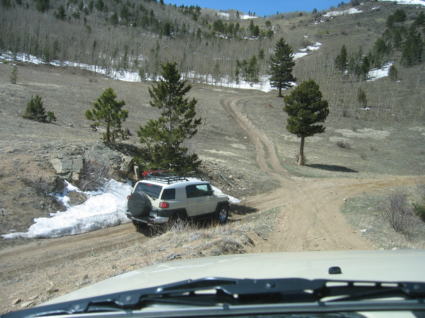
Between Gold Hill Rd. and a dead end to the West (~3.4 miles)
Lots of tight spots in this section with harsh brush that WILL cause
pinstripping It’s seen very little traffic over the years (relative to the
other sections), especially since they put Saw Mill Rd. through and caused a
landslide that cut off the far Northern end of the ST (and honestly I got here
after that. So, I have no idea if it ever went back out somewhere on the other
end anyway).
This section has a fun, rocky hill climb for the drier/warmer time of the year,
but we usually don't get in here much when it’s snow-covered, because it is
usually inaccessible to most rigs in winter due to a nearby resident plowing
snow up right on the trail that’s almost impossible to get passed.
|
? What do you |~_~| |